


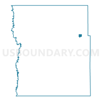
Hitterdal Voting District, Clay County, Minnesota
About
Outline

Summary
| Unique Area Identifier | 601537 |
| Name | Hitterdal Voting District |
| County | Clay County |
| State | Minnesota |
| Area (square miles) | 0.94 |
| Land Area (square miles) | 0.86 |
| Water Area (square miles) | 0.08 |
| % of Land Area | 91.47 |
| % of Water Area | 8.53 |
| Latitude of the Internal Point | 46.97856720 |
| Longtitude of the Internal Point | -96.25850520 |
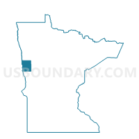
Maps

Graphs
Select a template below for downloading or customizing gragh for Hitterdal Voting District, Clay County, Minnesota


Neighbors
Neighoring Voting District (by Name) Neighboring Voting District on the Map
- Goose Prairie Twp. Voting District, Clay County, MN
- Highland Grove Twp. Voting District, Clay County, MN
Top 10 Neighboring County Subdivision (by Population) Neighboring County Subdivision on the Map
- Highland Grove township, Clay County, MN (288)
- Hitterdal city, Clay County, MN (201)
- Goose Prairie township, Clay County, MN (175)